Satellite Communication
The early 1980s witnessed the satellite communication revolution in India, with the INSAT satellite network steered by the Indian Space Research Organization (ISRO). Satellite-based communication systems can provide coverage to the remotest and most inaccessible areas of a geographically widespread country like India. The demand for satellite bandwidth is growing in light of increasing communication needs for socio-economic development, connecting inaccessible areas, proliferation of broadband services, increasing online consumer services, use of connectivity for disaster management, and use of digital technology for national security.
Many sparsely populated areas, including areas of strategic importance and areas important from the socio-economic angle, do not have mobile terrestrial coverage or other forms of connectivity. Satellites can bridge this gap by providing connectivity and provide telecom and broadcasting services to even the remotest areas.
Satellites have the advantage of communicating and collecting data from virtually anywhere without being hindered by terrestrial coverage limitations. So, new satellite technologies can be used to provide ubiquitous coverage across the country.
Satellite-based services include:
(i) Remote Sensing and Imaging: Remote sensing satellites detect both visible lights for photographs as well as electromagnetic radiation used for microwave, ultraviolet, infrared, radio, and other types of sensing. This information is used by weather forecasters, farmers, scientists, government users, and a host of other users.
(ii) Mobile Communications: Mobile communications satellites provide ubiquitous voice and data services to users virtually anywhere, far beyond the coverage provided by cellular or terrestrial networks.
(iii) Broadband Connectivity: Many communications satellites provide high-speed broadband services globally. Several LEO constellations are being launched for providing broadband connectivity to users on the land, sea, and air.
These satellites provide connectivity for:
1. Broadband services to the unconnected remotest and
rural regions.
2. Maritime broadband.
3. In-flight connectivity (IFC) broadband services.
(iv) GPS and Navigation: GPS satellites provide location-based services for navigation devices, including the average smartphone. They also serve billions of customers with timing information, which is critical for the operation of everyday services.
(v) Disaster Management: Satellite connectivity can help restore the services in the situation of disasters, where the terrestrial networks get damaged. This makes satellite services uniquely reliable and an invaluable tool for disaster relief management. Satellites can also provide valuable services post-disaster and backhaul capacity for network restoration.
(vi) Broadcast: Satellite TV & Radio Broadcast satellites transmit video of live news and sporting events so that viewers around the world can watch these events live.
(vii) IoT and M2M: Satellite data can connect IoT and M2M devices even when operating far beyond the coverage of terrestrial networks.
(viii) Telemedicine: Satellite data services help connect the patients in rural and remote regions with doctors virtually.
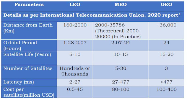
In order to provide the above-mentioned services, satellite orbit is selected based on the requirements of the application. Satellite orbits can be categorized as Geostationary Earth Orbit (GEO), Medium Earth Orbit (MEO), or Low Earth Orbit (LEO). MEO and LEO orbit satellites are collectively called Non-Geo Stationary Orbit (NGSO) satellites. The brief comparisons of the three Satellite System orbits are enumerated in the following Table.
Reference:
Consultation PaperonLicensing Framework for Establishing Satellite EarthStation Gateway ( This consultation paper also gives detailed explanation on legal and licensing rerequirements for starting satellite based telecommunication services in India ).


Comments